El Caminito del Rey: the most popular hiking trail in Málaga
Are you visiting Málaga (Spain)? Do you love nature and are feeling adventurous? Then the hike known as ‘El Caminito del Rey‘, literally meaning ‘the King’s little pathway’, is your ideal getaway. Located in a deep gorge amidst breathtaking landscapes, discover this renowned hiking trail and even cross over a picturesque suspension bridge. After my experience exploring ‘el Caminito del Rey‘, in this post I’ll share everything you should know ahead of your visit so you can plan accordingly. I will also answer some of the most burning questions you might have. Let’s get started!
***
Disclaimer:
- I’ve visited Málaga various times over the years, the last one being in January 2024. This updated post is a compilation of prior trips and reflects the latest information available.
- Please note that this post includes some affiliate links. This means that, at no additional cost for you, I earn a commission if you make a purchase. In case you have any question about the companies advertised here or my status as an affiliate, please do not hesitate to contact me.
***
👑 What is ‘El Caminito del Rey’? Brief history and context
Literally meaning the King’s little pathway (‘El Caminito del Rey‘ or also simply referred to as ‘el Caminito‘ in Spanish), this is the most famous hiking trail in the Málaga province.
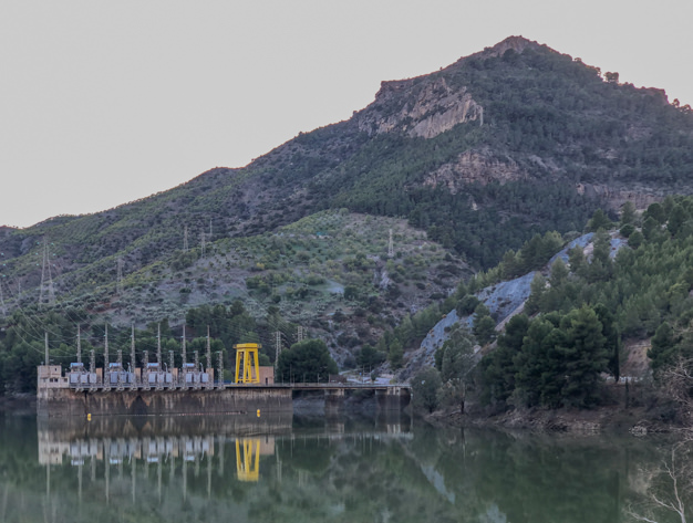
Built at the beginning of the 20th century (1901-1905) under the leadership of the engineer Rafael Benjumea, the original walkway known as ‘los Balconcillos de los Gaitanes‘ enabled the workers at the Hydroelectric Power Station El Chorro to cross between both sides: Salto del Chorro and Salto del Gaitanejo. Similarly, it ensured the transportation of equipment and helped facilitate the inspection and maintenance of the water canal in the premises.
In 1921, King Alfonso XIII crossed the pathway when he inaugurated the nearby Conde del Guadalhorce dam, hence giving it its present name.
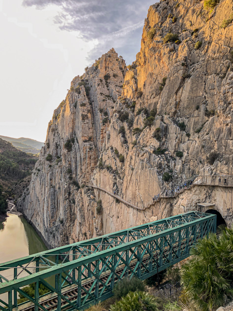
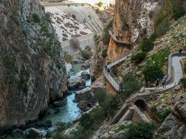
Located in Andalucía, in southern Spain, el Caminito del Rey is an aerial walkway built in the walls of the imposing Gaitanes gorge, which was excavated by the Guadalhorce river over centuries. The hiking trail is part of a natural park known as Paraje Natural Desfiladero de los Gaitanes.
Over 300.000 people visit el Caminito del Rey every year, making it one of the best-known tourist attractions in the region of Málaga.
For more nature-based inspiration, check out these posts!
Camino de Santiago: hiking from Irún to Deba along the ‘Camino del Norte’
Discovering the Austrian Alps: Kaprun, Maria Alm, Saalfelden & Zell am See
El Saltillo: hiking the Gran Senda de Málaga from Canillas de Aceituno
Exploring the Sama mountain range
Reserva Nacional de Fauna Andina Eduardo Avaroa (I)
Reserva Nacional de Fauna Andina Eduardo Avaroa (II)
What to see and do in Iceland in 4 days
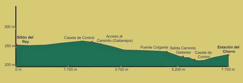
🥾 How long is El Caminito? Distance, time and itinerary
When exploring El Caminito del Rey, consider the total distance you may end up hiking is 7 to 8 km, with more than half of the itinerary being access ways (between 3.6 km and 4.8km), and the rest being the walkway itself (2.9km). All in all, the whole itinerary can take you from 3 to 4 hours.
Starting north in Ardales, el Caminito del Rey is a linear route that extends south to the villages of Antequera and Álora. The walkway is one-way, meaning that once you’ve reached the end of the itinerary, you need to either walk back or take the shuttle bus to where you parked your car (unless you left it in the P2 parking located south near the exit, which is the option I recommend).
To make it simple, these are the distances and stops along your hiking trail depending on where you’re starting from:
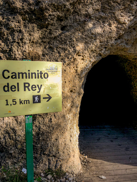
- Beginning of the itinerary from the first tunnel (2,7 km; Senda de Gaitanejo starting right next to El Kiosko restaurant) or the second tunnel (1,5 km; Pista de Gaitanejo beginning 200 meters before the same restaurant). Upon arrival, you will reach the visitor center or caseta de control located north.
- Walkway (Caminito del Rey): 2,9 kilometers
- Exit through the second caseta de control located south: 2,1 km
For your ease of reference, let’s break down the various legs throughout the itinerary of the Caminito del Rey itself (almost 3 km):
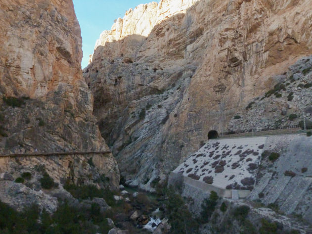
- Desfiladero de Gaitanejo: this is the first gorge you will come across; it is quite a narrow one and you will even see the Guadalhorce river running underneath.
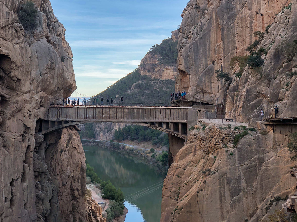
- Tajo de las Palomas: second gorge along the hiking trail. From this point onwards, you’ll notice the railway and a series of tunnels on the other side. It must be such an imposing ride!
- Valle del Hoyo: this part of the itinerary is wider compared to the previous ones and is a great rest area to take a break in case you’re doing a self-guided tour.
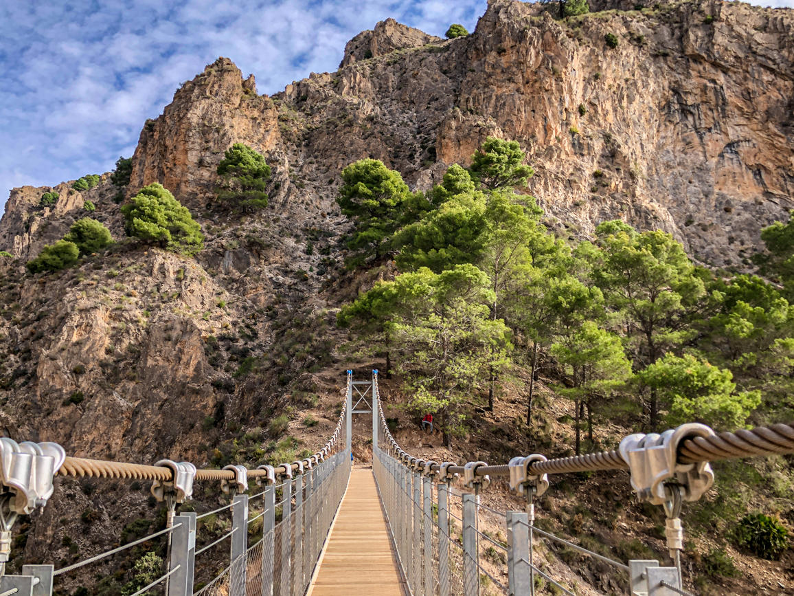
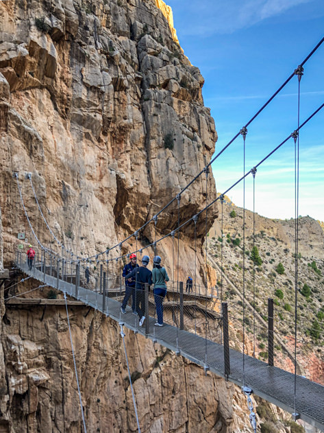
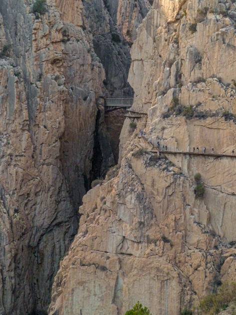
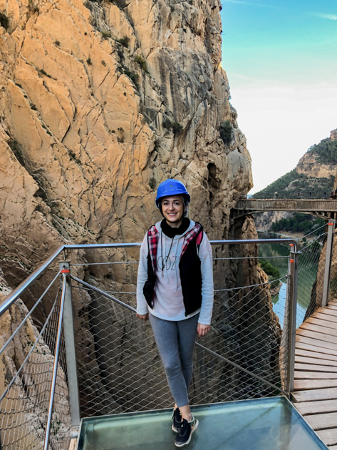
- Desfiladero de los Gaitanes: welcome to the third and last gorge throughout the itinerary! Actually, this is the most impressive one, with the walkway lying at 100 meters high. Before crossing the suspension bridge, pay attention to the remains of the original walkway under the renewed structure. Bonus point if you find an ammonite, a fossil dating back 180 million years!
- Suspension bridge (puente colgante): this is the main star of the hiking trail for most visitors. The suspension bridge connecting both sides of the gorge is 15 meters long and totally safe. In case you’re afraid of heights or get vertigo easily, don’t look down! If not, enjoy the breathtaking view of the reservoir and the vertical gorge walls. After crossing the suspension bridge, the walkway continues and turns left for another 10 minutes before a series of steep stairs.
- Tajo de la Encantada: hike along the pathway for 2 more kilometers, parallel to the reservoir and the railway, until you reach El Chorro train station (estación del Chorro). On your way, you will pass by a chapel (Ermita de la Virgen de la Medalla Milagrosa) that once served as a school for the workers’ kids of the Hydroelectric Power Station in El Chorro. Once you’re there, you can drop your helmet and return to the nearby P2 parking to get your car or hop on the shuttle bus to head north.
You can also check out the whole itinerary for further details.
Feeling adventurous? Check out these outdoor activities with Manawa in Caminito del Rey.
Caminito del Rey Excursion, Malaga
Guided tour to the caves of Nerja and the village of Frigiliana, Malaga
Hot Air Balloon Flight over Antequera, Malaga
Private Boat Tour from Benalmadena, Malaga
Rafting Excursion on the Genil River, Malaga
Vía Ferrata Caminito del Rey in El Chorro
💪 How hard is it to hike El Caminito del Rey (Spain)? Difficulty and recommendations
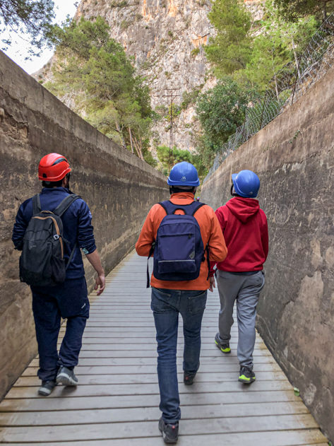
In my opinion, hiking El Caminito del Rey was easy as the one-way walkway was mostly flat, with barely no unevenness along the way. That being said, and given the total distance you’ll be hiking, make sure you’re fit and in good physical condition to avoid any unpleasant surprises. I wouldn’t recommend visiting if you get vertigo or suffer from heart-related or breathing difficulties. Kids who are under 8 years old are not allowed. Always follow the recommendations on-site and bear these prohibitions in mind.
Wearing appropriate footwear and comfortable clothing is highly recommended. Similarly, remember to bring water, snacks and sunscreen, especially during the summer months.
Last but not least, there are no toilets or bins throughout the itinerary, so keep any rubbish on you until the end of the hike.
🦺 Is it safe to hike along El Caminito del Rey?
Many years ago, el Caminito del Rey was considered extremely dangerous given its poor maintenance, severe damage and a series of fatal accidents that took place in the early 2000s.
After being closed for a period of time, the local and regional authorities decided to undertake a thorough renovation and the walkway was reopened to the public in 2015.
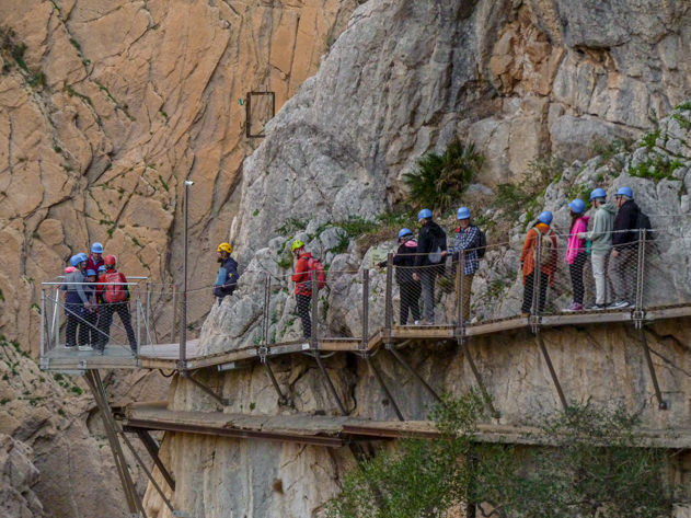
The current structure is 100% safe, featuring high protective handrails along the 1 meter wide walkway. Some legs of the trail rise over 100 meters above the river below.
Furthermore, once you reach the visitor center located in the north entrance, you’ll be handed a mandatory helmet that you’ll have to wear at all times throughout the entire itinerary.
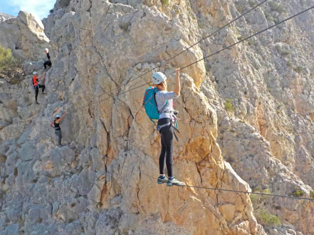
For the most adventurous travelers, note that after hiking El Caminito del Rey, you can continue on a via ferrata. Local companies such as Aloratur or Triángulo Activo Caminito del Rey offer this kind of service, including climbing steps, a Tibetan bridge, a Nepali bridge and a 35 meter long zip line. However, I would recommend this activity to courageous people only! 🙂
If you wish to go even further, you can hike Pico Huma, a peak that is almost 1,200 meters high and is considered the balcony of Andalucía as it overlooks parts of this vast region in southern Spain. Other nearby trails include the following: Sendero Ruta de las Lagunas, Sendero Teba-Embalses, Gran Senda de Málaga (GR 249), Camino Geológico Malacitano (GR 340).
🎟 Tickets to visit El Caminito
Head to the official website to buy your tickets for El Caminito del Rey. Please note that tickets might not be available if you’re trying to book them way before your scheduled visit date. Also, kids under 8 years are not allowed.
There are two types of tickets:
- General (10 euros): it allows you to go on a self-guided tour.
- Official guided visit (18 euros): during the tour, you’ll be accompanied by a group led by a certified guide. I would advise you pick this option if you want to fully enjoy the experience and learn a great deal of information about the history, local wildlife and flora as well as curious anecdotes of this breathtaking destination.
When purchasing your ticket to hike along El Caminito del Rey, you may also want to book your tickets for the shuttle bus (2.5 euros/person) and the Visitors’ Reception Centre Parking (P) at another 2 euros/day. Alternatively, you can pay for the shuttle bus on the spot in cash and leave your car in any other parking that may be available (P1 costing 2 euros/day or P2 – currently free as it’s being refurbished).
Would you like to explore other destinations in Spain?
A guide to the Feria de Abril in Sevilla
Granada travel guide: best things to see and do in 24 hours
My top five museums to visit in Guipúzcoa
Top things to do in Málaga, the capital of Costa del Sol (+ map)
Top things to do in Sierra de Aracena (Huelva): travel guide + map
What to do in Barcelona: my travel guide to Catalonia´s capital
What to see in the Málaga province: 12 destinations inland & along Costa del Sol
🚗 How to get to El Caminito del Rey: transportation options and access
There are different ways of reaching el Caminito del Rey. Let’s see them one by one in more detail:
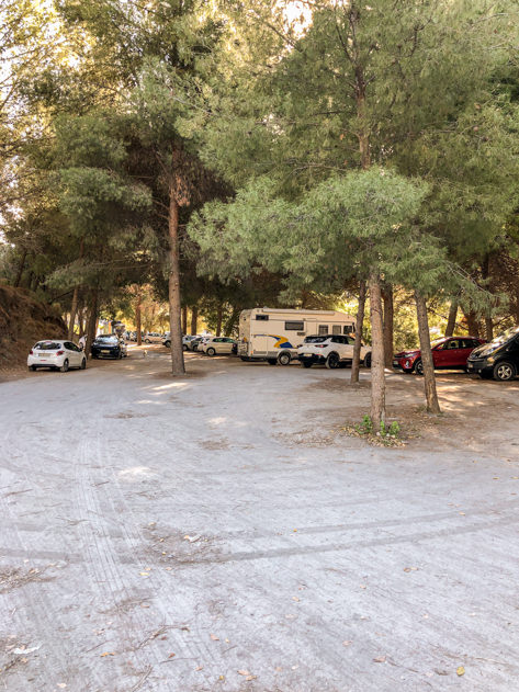
- By car: if you’re coming from Málaga, drive via the A-357 until the junction in Ardales, where you will take the MA-5403 exit. Upon arrival, you can choose among three parkings (P, P1 or P2). On the one hand, the Visitors’ Reception Centre Parking (P) costs 2 euros/per day, the ticket can be purchased through the official website and the shuttle bus stops here. On the other hand, P1 parking is located north, also costs 2 euros but the ticket cannot be purchased online, and the shuttle bus makes its final stop here. Last but not least, P2 parking is free, it can be found south, after the end of the hiking trail, and is currently under renovation while still in use. The shuttle bus departs from and arrives to the train station near the P2 parking and next to Hotel La Garganta, making it an ideal option after you’ve finished the hike.
- By train: you can easily reach the El Chorro / Caminito del Rey station in around 50 minutes from the María Zambrano or Málaga Centro RENFE train stations in Málaga on board the C2 line. A one-way ticket costs €4.40 while the round trip is €7.
Once you’ve arrived to your destination, you have two options to get to the visitor center in the north entrance that will give you access to El Caminito del Rey. Remember that the hiking trail is linear (north to south) and not circular.
- By shuttle bus and then by foot: note that there’s a shuttle bus connecting the three parkings, including the ones lying north and south. Whether you’ve left your car in parking P or P2, you may hop on the shuttle bus that will stop nearby on its way to the second tunnel that gives access to the visitor center. From there, you’ll have to walk 1.5km until you reach the visitor center. You can either purchase your shuttle bus ticket online for 2.5 euros/person (it will be scanned) or pay on the spot in cash, as cards aren’t accepted. The bus trip lasts between 15 and 20 minutes. In both cases, arrive to the parking at least an hour ahead of your scheduled time for the visit given the low frequency of the buses.
- Entirely by foot: should you not want to take the shuttle bus, you can walk from your designated parking to the first or second tunnel that will give you access to the visitor center.
TIP: if you’re driving to El Caminito del Rey, I would recommend you leave your car in the P2 parking. Since it’s free and located at the end of the hiking trail, you’ll return to your car right after you’re finished.

Where to eat and sleep near El Caminito del Rey
Even though El Caminito del Rey is rather secluded, there are a number of places nearby where you can eat and sleep.
🍽 Bars & restaurants
- La Garganta Restaurant: located in La Garganta Hotel, this restaurant awarded with a Solete Repsol offers delicious traditional cuisine featuring exquisite local products and dishes such as fresh goat cheese, perotas soups (typical from Álora), migas or goat in aloreña sauce. The restaurant is open all day long to all visitors. Make sure to eat a bite or enjoy a full lunch in one of its terraces or dining rooms while admiring panoramic views of the Caminito del Rey.
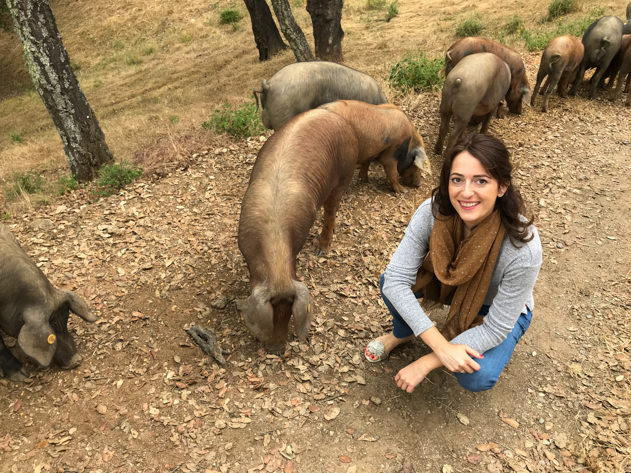
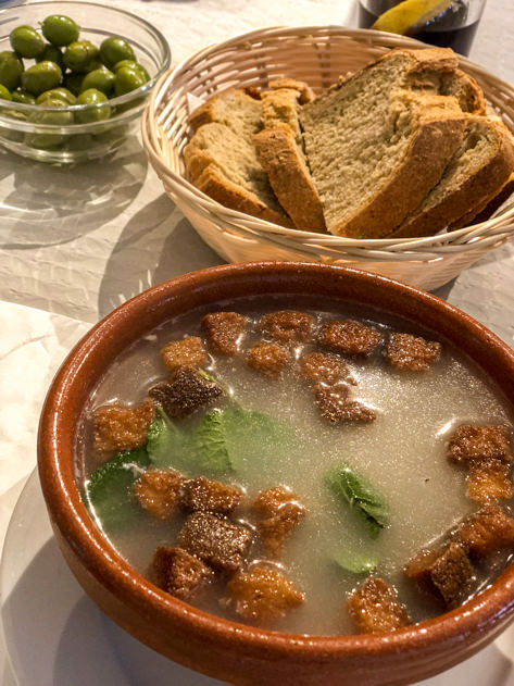
- Bar El Pilar: before our hike along the Caminito, we had lunch at this modest restaurant offering affordable homemade meals, steps away from the P2 parking in El Chorro. We ate a delicious daily menu for 10 euros/person including a soup (sopa de picadillo), meatballs (albóndigas) and a vanilla crème caramel for dessert. You can either eat inside or outside while contemplating the Tajo de la Encantada reservoir.
- Restaurante El Kiosko: because of its strategic location next to one of the tunnels giving access to the Caminito del Rey visitor center, this restaurant in Ardales is another great option to eat before or after your hike. It features traditional cuisine with a dining room and terrace overlooking the Conde del Guadalhorce reservoir.
For more dining options, I suggest you ask the locals around and browse the bars and restaurants in the nearby villages.
🛏 Accommodation
- Hotel La Garganta: this hotel is uniquely located at the end of the Caminito del Rey hiking trail and next to the train station, shuttle bus stop and P2 parking. Originally built as a flour factory, its 25 modern rooms are fully equipped and provide the perfect getaway in the middle of nature. Take advantage of the panoramic swimming pool and taste local cuisine at the restaurant.
- Hotel Mesón La Posada del Conde: ideally located near the north entrance and the historic Sillón del Rey, this small hotel is an excellent gateway to the Caminito del Rey and its surroundings. Check out its restaurant while you’re there.
Should you want to browse additional options to sleep around El Caminito del Rey and the Paraje Natural Desfiladero de los Gaitanes in the region of Málaga, feel free to look these on Airbnb and Booking. Camping or sleeping in cottages known as casas rurales can be a great idea as well!
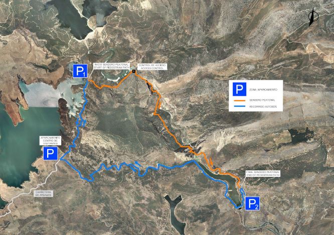
📍 Map to get around El Caminito del Rey
In the map below you will find all the locations mentioned throughout this post, from the main access points and parkings, to the villages worth sightseeing to local hotels and restaurants. Save it for your next trip!
🧳 Day trips from El Caminito del Rey
Around the Caminito
El Caminito del Rey is certainly the main highlight of this area, but I would suggest you also devote some time to exploring the surroundings either before or after the hike.
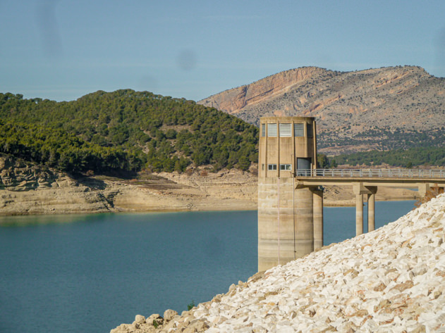
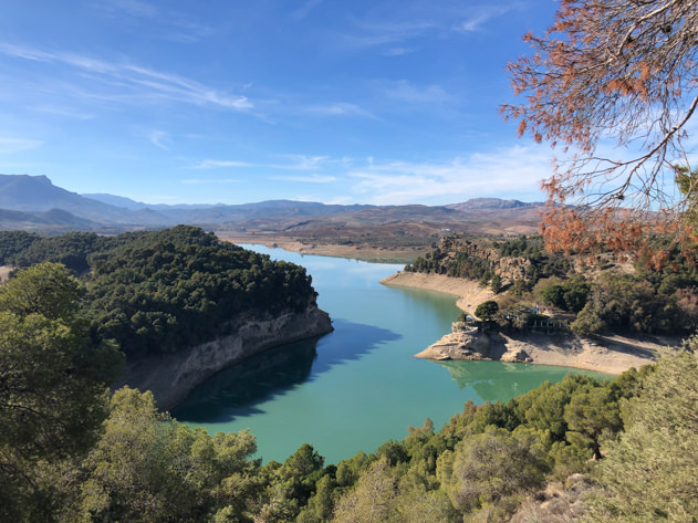
As a matter of fact, this hiking trail is encircled by three reservoirs known as Los Tres Embalses. Namely, the reservoirs are: Embalse Conde de Guadalhorce (also known as ‘Pantano del Chorro‘), Embalse del Guadalhorce and Embalse del Guadalteba.
These dams actually offer a great panoramic view to admire the natural beauty around them. Some viewpoints worth mentioning include the following:
- Mirador al Chorro
- Mirador Cerro Pardo
- Mirador de las Buitreras
- Mirador de los Tres Embalses
- Mirador el Sopandro
- Mirador right above Restaurante el Kiosko
These reservoirs also host some inland beaches that are popular among nautical sports lovers, especially during the summer. In 2021, the reservoir Conde del Guadalhorce was awarded with a blue flag (Bandera Azul) for meeting a series of criteria of quality, safety, hygiene, provision of services and care for the environment. However, the drought in subsequent years meant the loss of that distinction.
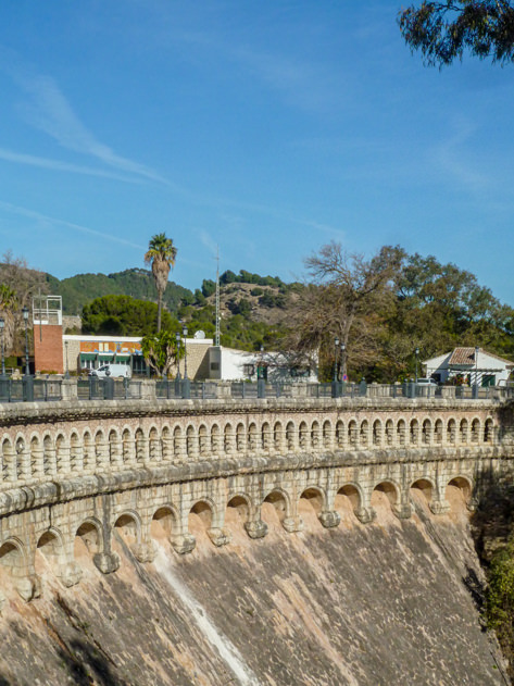
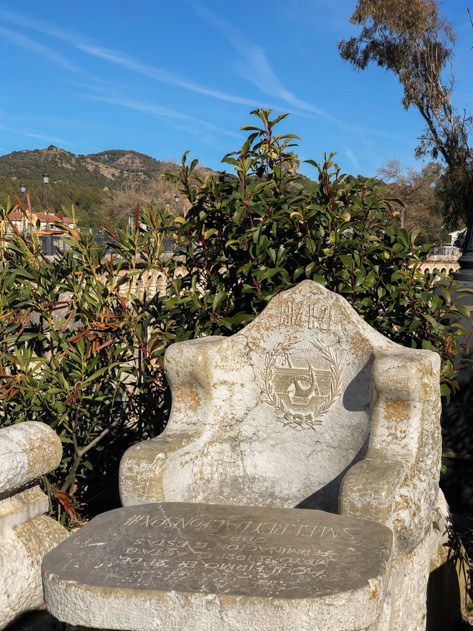
Another place worth checking out while you’re exploring the nearby Caminito del Rey is the King’s Chair or Sillón del Rey. Lying next to the Conde de Guadalhorce dam, this set of an armchair and two benches made of stone was built in honor of Spanish King Alfonso XIII, when he signed the completion of the construction of the reservoir in 1921. From there, to the other side of the dam, you will find the House of the Engineer (Casa del Conde) that is currently closed.
Furthermore, here are some ideas of nearby inland villages to explore around the Caminito del Rey: Álora, Antequera, Ardales, Campillos, Carratraca, Casarabonela, Pizarra, Teba and Valle de Abdalajís.
Málaga & Costa del Sol
Should you want to head to the coastline, the capital city of the region – Málaga – is always a great idea thanks to its rich heritage, interesting museums and lively buzz.
Along the sunny coast of the Málaga region known as Costa del Sol, you will be able to unwind and relax in front of the Mediterranean Sea in beach destinations such as Benalmádena, Nerja or Marbella. Enjoy!
🛍 Shop my hiking look
As mentioned before, it is key to feel comfortable while hiking for hours. Below are some of the sports equipment that I used during my itinerary along the Caminito del Rey. You can also check out my Decathlon affiliate profile to create your own outfit.


I hope that this post about the popular hiking trail of ‘El Caminito del Rey‘ was helpful and inspired you to discover this fascinating destination in the Spanish region of Málaga. In case you have some more questions or would like to drop a comment, feel free to do so below! Thanks for reading and ’til the next post! 🙂
***
✈️ Curious to know where I’ll be traveling next? ✈️
Stay tuned by following me on social media (Facebook, Instagram, X) and subscribe to my newsletter for regular updates!
In the meantime, safe travels around the world!
***
| GET READY FOR YOUR NEXT TRIP! |
|---|
| Book memorable activities and tours around the world with Get Your Guide. |
| Browse my travel resources page to plan your upcoming trip. |
| Check out my travel photography prints inspired by cities I’ve visited around the world. |
| Feeling adventurous? Book any outdoor activities worldwide with Manawa! |
| Get medical or health insurance via SafetyWing for extra peace of mind. |
| Looking for sports equipment? Feel free to browse my Decathlon profile for inspiration. |
| Pay in local currency with your Revolut Card when you’re traveling abroad! |
| Stay at my apartment while I´m away (Airbnb, Booking). |